


 by
by We drove to Salaulim Dam twice before figuring out the right route. The first time? Wrong turn, dead-end dirt track, and a local farmer redirecting us with a bemused smile. The second time, we cracked it — and realized why most online guides miss the actual access points entirely.
Here’s what you won’t find on travel blogs: Salaulim Dam Goa has three approach routes, but only two are reliably drivable year-round, and none of them match what Google Maps suggests as the “fastest route.” We learned that the hard way, with dust on our car and confusion in our heads.
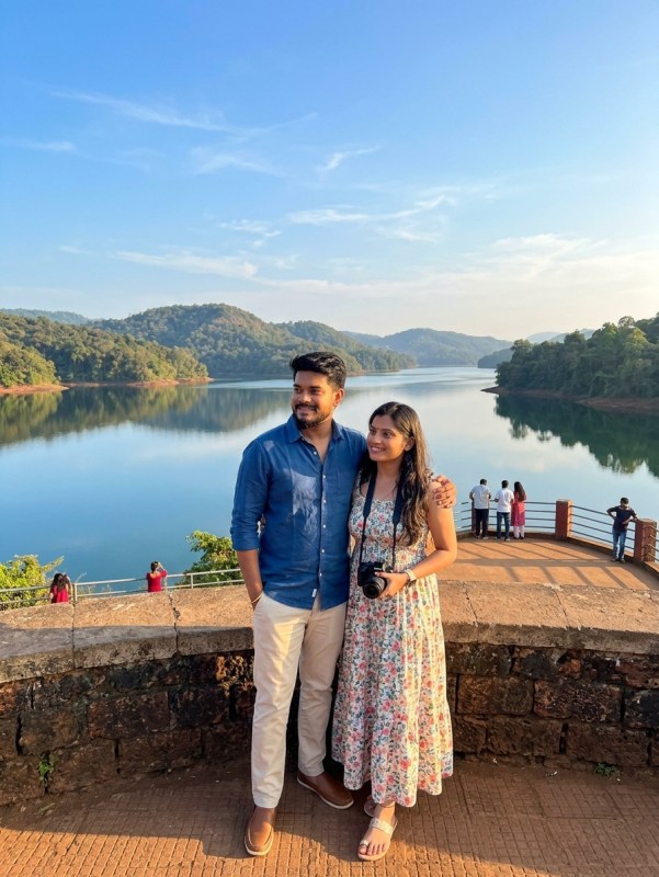
If you’re planning to visit Salaulim Dam, you’re probably wondering whether it’s worth the drive, which road actually gets you there, and what the real conditions look like beyond the Instagram shots. We’re Ketan and Samprita from Musafir Couple, and we’ve driven these routes in monsoon, summer, and post-rain conditions. This is the complete access guide with the friction, the costs, and the honest verdict.
Why Salaulim Dam Access Confuses Most First-Time Visitors
Most travel content treats Salaulim Dam like a simple pin-drop destination. It’s not.
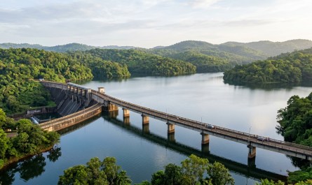
The dam sits across the Salaulim River in South Goa, connecting Sanguem and Canacona talukas. What makes access tricky is that the dam itself is a long structure, and “visiting Salaulim Dam” can mean reaching the dam wall, the reservoir viewpoint, or the backwaters depending on which route you take. Each approach lands you at a different vantage point.
We met a couple from Pune near the Netravali side who’d driven 40 minutes past the actual dam access thinking they were heading toward it. They were following a maps pin that led to a walking trail, not a vehicle approach. That’s the core issue — most digital directions don’t distinguish between the dam viewpoint accessible by road and the trekking routes that loop around the reservoir.
When you search “how to reach Salaulim Dam,” you get a mishmash of directions to nearby villages, wildlife sanctuary gates, and forest department checkpoints. None of that tells you which road is paved, which needs ground clearance, or which one actually delivers a clear view of the dam structure itself.
Here’s what worked for us: think of Salaulim Dam access in terms of approach sides, not a single destination. One route from the Sanguem side, one from the Canacona-Netravali side, and a third forest-adjacent track that’s seasonal and often restricted.
Route 1: Sanguem Side Approach — The Paved and Practical Option
This is the route most travelers should take if they want a reliable, all-weather road to the dam.
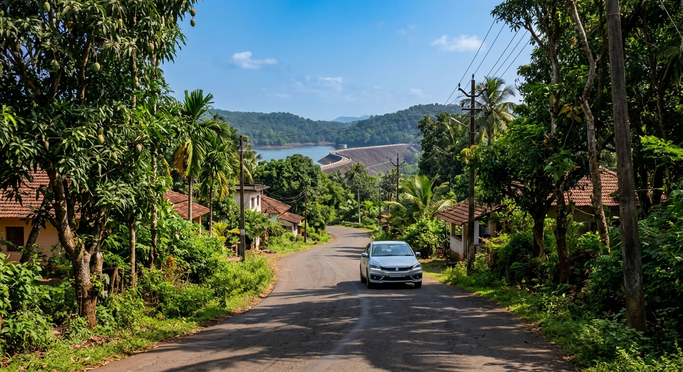
Start from Margao and head toward Sanguem via NH748. About 22 kilometers from Margao, you’ll reach Sanguem town — a proper junction with petrol pumps, small eateries, and local shops. From Sanguem, take the road toward Molcornem village. This stretch is paved but narrow in sections, with light traffic and occasional potholes after monsoon.
The Sanguem approach brings you to the dam wall itself, with a small access road that descends toward the water level during dry months. We visited in February, and the road was completely drivable right up to a clearing near the dam structure. During peak monsoon, the lower access gets submerged, but the main viewing area stays reachable.
What we liked: proper road surface, mobile network coverage most of the way, and locals who actually know the dam location if you need to ask for directions. What we didn’t like: limited parking space near the dam, and no signboards once you’re within 2 kilometers of the site.
Fuel cost from Margao to Salaulim Dam via Sanguem: approximately ₹80-100 for a sedan, depending on your driving style. No tolls on this route. Estimated driving time: 50 minutes to 1 hour from Margao, accounting for village road speeds.
One tip from experience — fill fuel in Sanguem itself if you’re running low. The next reliable pump is back toward Margao or deeper into Canacona, neither of which you want to detour for.
Route 2: Canacona-Netravali Approach — Scenic but Rougher in Patches
This route takes longer but offers better scenery, especially if you’re combining the dam visit with Netravali’s bubble lake or the Savari waterfalls.
From Canacona (near Palolem), head inland toward Netravali village via Cotigao road. This stretch is about 18 kilometers and mostly paved, though narrower and less maintained than the Sanguem route. Once you reach Netravali, follow local signs or ask for “Salaulim backwaters” — the road forks, and the left turn takes you along the reservoir’s edge.
This approach doesn’t bring you to the dam wall but to a viewpoint overlooking the backwaters. It’s quieter, more forested, and frankly more photogenic if you’re after reflections and wide water views rather than the dam structure itself. We stopped here on our second visit and spent a good 30 minutes just watching the water shift color as clouds moved.
Road conditions: paved until Netravali, then a mix of concrete village road and dirt track for the last 3-4 kilometers. Ground clearance helps here — we managed in a hatchback, but a couple of scrapes on speed breakers reminded us why an SUV would’ve been easier.
Fuel cost from Palolem to Salaulim via Netravali: roughly ₹60-80. No tolls. Driving time: about 50 minutes, slower if you stop for photos or navigation checks.
The Canacona route makes sense if you’re staying in South Goa and want a half-day trip combining Netravali and Salaulim. If you’re coming from North Goa or Margao, the Sanguem route is faster and simpler.
The Forest Track Route — When It’s Open and When to Skip It
There’s a third access route that loops through forest department land, connecting the Molcornem side to the backwater trail. Locals use it, and we spotted a few adventure groups attempting it in Thar and Scorpio vehicles.
Here’s the reality: it’s not a marked tourist route. The track is unpaved, heavily rutted in sections, and often gated by the forest department during monsoon and wildlife movement seasons. We were told by a forest guard near Netravali that this route is “allowed but not encouraged” for private vehicles, and during our visit in February, the gate was open but the track was muddy enough to deter most sedans.
If you’re in a 4×4 and traveling in dry season, this route offers a proper off-road experience and connects the two main approaches. But if you’re a first-timer or driving a regular car, skip it. The Sanguem and Netravali routes cover all the access you need without risking a stuck vehicle or a forest department questioning.
We didn’t attempt this route fully — partly because our car wasn’t built for it, and partly because the backwater view from Netravali already gave us what we wanted. But if you’re planning it, check with locals in Molcornem or Netravali village first. Conditions change weekly during monsoon.
Real Road Conditions: What Google Maps Won’t Show You
This is where most online guides fail you. They list distances and routes but say nothing about the actual road surface, traffic, or navigation quirks.
The Sanguem route is the smoothest overall, with paved roads covering about 90% of the distance from NH748 to the dam area. The last 2 kilometers narrow down to a single-lane village road shared with tractors, two-wheelers, and the occasional bus. We encountered a local school bus on the return, and reversing 50 meters to let it pass was the polite move — these roads don’t have formal passing zones.
The Canacona-Netravali route is narrower and winding, especially through Cotigao forest stretch. Expect overhanging branches, uneven edges, and limited visibility on turns. We drove this route around 10 AM, and oncoming traffic was light. Later in the day, local commuters and tourist taxis increase, making passing tricky. Mobile network drops in patches here, so download offline maps before you leave Canacona.
Both routes have minimal signage. We relied on asking shopkeepers, bike riders, and one very helpful aunty selling cashew feni near Netravali. She not only pointed the right turn but warned us about a puddle that “looks shallow but isn’t” — accurate intel that saved us a potential mess.
Parking at the dam: there’s no official lot. On the Sanguem side, you park along the access road or in a clearing near the dam wall. On the Netravali side, you park where the paved road ends and walk about 100 meters to the viewpoint. No parking fees, no attendants, no security. Keep valuables out of sight.
Rainy season changes everything. We haven’t driven these routes in peak monsoon, but locals told us the Sanguem approach gets waterlogged near the dam in July-August, and the Netravali track becomes slippery enough to discourage even experienced drivers. If you’re visiting between June and September, call ahead to a Sanguem or Netravali local contact to confirm access status.
What to Expect at Salaulim Dam — Beyond the Arrival
You’ve driven the route, navigated the turns, and reached the dam. Now what?
From the Sanguem side, you’re standing near the dam wall with a direct view of the spillway and reservoir. During dry months (December to May), water levels drop significantly, exposing rocks and sandbars. It’s less dramatic than monsoon-fed reservoir views but more accessible for walking around and exploring.
We visited in February, and the water was calm, the surrounding hills were dry, and the silence was absolute. No hawkers, no crowds, no entry tickets. Just us, the dam, a few local fishermen casting lines from the rocks, and a pair of eagles circling overhead. It felt raw in the best way.
From the Netravali side, you’re looking across the backwaters — wide, forested, and peaceful. This vantage point suits photography better than the dam wall view. The reflections here, especially in early morning or late afternoon light, are worth the rougher drive.
What you won’t find: food stalls, restrooms, guides, or tourist infrastructure. Salaulim Dam is not developed for tourism the way Dudhsagar or Chapora Fort are. That’s part of its appeal if you value solitude, and part of its challenge if you expect facilities.
Carry water, snacks, and a charged phone. The nearest eatery on the Sanguem route is back in Sanguem town — basic Goan cafés serving fish curry rice, poi, and chai. On the Netravali side, you’re looking at roadside stalls near Cotigao or heading back to Canacona for a proper meal.
Time to spend: we stayed about 90 minutes on our first visit, walking along the dam, sitting by the water, and chatting with a local who was repairing his fishing net. Second visit from Netravali side, we stayed about an hour. It’s not a full-day destination unless you’re combining it with Netravali bubble lake, Savari waterfalls, or a longer South Goa exploration loop.

Best Time to Visit Salaulim Dam and Why It Matters
Timing changes the entire experience at Salaulim Dam Goa, and most guides skim over this.
Monsoon (June to September) turns the reservoir lush and full, the spillway active, and the surrounding forest vibrant green. It’s visually the most dramatic, but access becomes difficult. Roads flood in sections, the forest track is off-limits, and even the Sanguem approach can get waterlogged near the dam. If you’re determined to visit in monsoon, go in late August or early September when rains ease but water levels stay high.
Post-monsoon (October to November) is ideal. Water levels are still good, roads dry out, greenery lingers, and tourist traffic is low. We visited Goa in October once, and Salaulim felt like a secret even locals had momentarily forgotten.
Winter (December to February) offers the best road conditions and weather but lower water levels. The dam view is less dramatic, but access is smooth, and you can walk around areas that are submerged in monsoon. This is the season for couples looking for a quiet drive and a picnic-style outing without the Instagram frenzy.
Summer (March to May) is hot, dry, and dusty. Water levels drop further, the landscape browns out, and frankly, the appeal diminishes unless you’re combining it with other cooler spots nearby. We wouldn’t recommend Salaulim as a standalone visit in peak summer.
Time of day: early morning (7 to 9 AM) or late afternoon (4 to 6 PM) offers the best light and cooler temperatures. Midday sun reflects harshly off the water, and there’s zero shade near the dam wall. We made that mistake once — arrived at 1 PM in February, and even winter sun felt relentless with no tree cover.
Is Salaulim Dam Worth the Drive? The Honest Verdict
This is the question we get asked most, and the answer depends entirely on what you’re comparing it to.
If you’re expecting a developed tourist spot with viewpoints, cafés, and Instagram setups — no, Salaulim Dam will disappoint you. Head to Dudhsagar or Chapora instead.
If you’re after an offbeat, peaceful spot where you can sit by a reservoir without fighting crowds, listen to actual silence, and drive roads that feel exploratory rather than touristy — yes, absolutely worth it. We’ve been to Cola Beach, Cabo de Rama, and half a dozen hidden Goa spots, and Salaulim ranks high for the “we have this place to ourselves” feeling.
The drive itself is part of the experience. The Sanguem route through Goan villages, the Netravali route through forest edges — both remind you that Goa has depth beyond beaches and shacks. You’ll pass toddy shops, small temples, laterite-walled homes, and stretches where the only sound is your engine and cicadas.
Cost-wise, it’s incredibly budget-friendly. Fuel from Margao or Palolem is under ₹100, no entry fees, no parking charges, no forced purchases. Pack your own snacks and water, and the entire trip costs you just fuel and time.
Effort-wise, it’s moderate. The Sanguem route is easy enough for first-timers. The Netravali route requires slightly more attention and navigation comfort. Neither is difficult, but both require accepting that you won’t have Google Maps holding your hand the whole way.
Our verdict from Musafir Couple: if you’re already exploring South Goa and have half a day free, Salaulim Dam is worth adding to your route. If you’re in North Goa with limited time, skip it — there are closer offbeat options. If you’re a couple looking for a quiet drive and a spot to just sit and talk without distractions, Salaulim delivers exactly that.
Practical Tips from Our Repeated Visits to Salaulim Dam
These are the small details that made our trips smoother, learned after doing it wrong the first time.
Download offline maps before you leave your hotel or homestay. Network drops significantly once you’re past Sanguem or deep into Netravali, and you don’t want to guess turns on village roads.
Ask locals confidently. We stopped at least three times each visit — once at a paan shop in Sanguem, once at a house in Molcornem, once at a small temple near Netravali. Everyone knew the dam, and directions were more reliable than our GPS.
Carry a physical paper map or screenshot key junctions before you start. We learned this after our first wrong turn — one screenshot of the Sanguem-Molcornem fork would’ve saved us 20 minutes of backtracking.
Fuel up in Sanguem or Canacona depending on your route. Don’t assume you’ll find a pump near the dam — you won’t.
Pack light snacks and at least 2 liters of water per person. There’s nowhere to buy anything near Salaulim itself. We carried banana chips, boiled eggs, and glucose biscuits on our second visit, and it made sitting by the dam far more comfortable.
Wear covered shoes, not flip-flops. The area near the dam has loose rocks, uneven ground, and the occasional thorn bush. Samprita wore sandals on our first visit and regretted it within 10 minutes.
If you’re visiting in winter, carry a light jacket. Sounds odd for Goa, but early mornings near the reservoir can get breezy and cooler than you’d expect, especially if you’re sitting still for a while.
Don’t expect phone signal for photos backup. We switched to airplane mode and relied on camera instead of constantly trying to upload. Saved battery, reduced frustration.
Respect local fishermen and villagers. We saw a few people fishing from the rocks and farmers working nearby fields. A simple nod or greeting goes a long way. These aren’t tourist guides — they’re people going about their day who happen to share this space with you.
Combining Salaulim Dam with Nearby Attractions
Salaulim Dam doesn’t demand a full day, so pairing it with nearby spots makes logistical sense.
If you’re taking the Netravali route, add the Netravali Bubble Lake (Budbudyanche Talle) and Savari Waterfalls to your itinerary. Both are within 10 kilometers, and the combined loop takes about 4-5 hours including travel and stops. We did this combination once, and it felt like a complete offbeat South Goa experience.
From the Sanguem side, you’re positioned well to explore Rivona Buddhist Caves (about 12 kilometers away) or continue toward Dudhsagar base via Mollem if you’re planning a multi-day trip. We didn’t combine these on the same day, but the road connectivity makes it feasible.
Cotigao Wildlife Sanctuary is en route if you’re coming via Canacona. It’s not a guaranteed wildlife sighting spot, but the forest canopy walk and trails add variety if you have extra time. Entry fee is nominal, around ₹50 for adults.
For couples staying in Palolem, Agonda, or Patnem, Salaulim makes a good morning trip before heading back to the beach by afternoon. The contrast of quiet reservoir in the morning and beach sunset in the evening works surprisingly well.
We also combined Salaulim with a lunch stop in Sanguem town on the way back — nothing fancy, just a local joint serving prawn curry rice and sol kadhi. It grounded the trip in real Goan rhythm rather than tourist-bubble dining.
Frequently Asked Questions About Salaulim Dam Goa
Is there an entry fee to visit Salaulim Dam?
No, there is no entry fee. Salaulim Dam is not a ticketed tourist site. You can visit freely, park where space allows, and explore the dam area without any charges. Just respect the space and leave no litter.
Can we swim in Salaulim Dam reservoir?
Technically, there’s no official restriction, but we wouldn’t recommend it. Water currents can be unpredictable, there are no lifeguards, and locals we spoke to advised against swimming due to depth variations and submerged rocks. If you want a swim, stick to Goa’s beaches or designated natural pools.
Which route is better for first-time visitors — Sanguem or Netravali?
Sanguem route is better for first-timers. It’s more straightforward, better paved, and brings you directly to the dam structure. Netravali route is prettier but slightly more complex to navigate, better suited for a second visit or for travelers comfortable with village roads.
Is Salaulim Dam safe for solo female travelers?
Yes, in our experience and based on what we’ve observed, the area is safe during daylight hours. Traffic is light, locals are helpful, and we’ve seen solo women travelers and small groups visiting without issues. Stick to daytime visits, avoid isolated spots at dusk, and trust your instincts as you would anywhere offbeat.
Visit Salaulim Dam with Confidence — Now You Know the Real Routes
Most travel content tells you Salaulim Dam exists. We’ve told you how to actually get there, which roads work, what to expect when you arrive, and whether it’s worth your time and fuel.
The Sanguem route is your reliable, all-weather option. The Netravali route is your scenic, slightly adventurous choice. Both deliver access to a peaceful, under-visited corner of Goa that still feels like a discovery rather than a destination.
We’re Ketan and Samprita from Musafir Couple, and we’ve driven these routes, made the wrong turns, and figured out the access so you don’t have to guess. Salaulim Dam Goa isn’t flashy, it isn’t Instagrammed to death, and it won’t hand you a perfect experience on a platter. But if you’re willing to drive a little further, ask a few locals, and sit quietly by a reservoir that doesn’t demand anything from you — it’s one of those rare spots that reminds you why offbeat travel matters.
Ready to plan your visit? Check our detailed South Goa road trip guides, honest homestay reviews, and real-cost itineraries on Musafir Couple. We share every route, every meal, every confusion — because that’s the trip, not just the destination.
Meta Title: Salaulim Dam Goa: Complete Access Guide & Road Truth 2026
Meta Description: Real routes to Salaulim Dam Goa, honest road conditions, which approach works best, costs, timing & verdict from Musafir Couple’s repeated visits.
Primary Keyword: Salaulim Dam Goa
Secondary Keywords: Salaulim Dam access guide, how to reach Salaulim Dam, Salaulim Dam road conditions, Goa offbeat dam visit